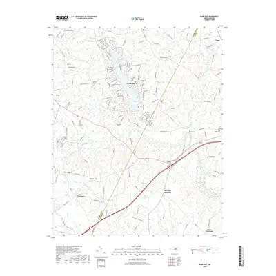
2019 Map of Bunn East
USGS Topo · Published 2019About this map
The Tar River and its numerous tributaries, including Turkey Cr and Coker Cr, carve a complex drainage pattern across this section of the Piedmont. Significant residential development is centered around Lake Royale, where a dense network of roads with names like Chickasaw Dr and Nakoma Dr surrounds the water. This modern lake community contrasts with the traditional rural character of the surrounding landscape, which is defined by several historic junctions such as Tants Crossroads, Gold Valley Crossroads, and Frazier Crossroads. Small aviation facilities like Spring Paths Airport and Crooked Creek Airport serve the local area, while crossing points such as Mullins Bridge and Anderson Bridge facilitate movement over the winding river. The eastern boundary is marked by the line between Franklin Co and Nash Co, showing how local geography and political boundaries intersect near the settlement of Seven Paths.
Find a feature on this map
144 named features on this map. Tap any name to fly to it.
Don’t see what you’re looking for? This feature index may not catch every label — zoom into the map to look around manually.
Map Details
Editions of this 2019 Bunn East Map
This is the sole edition of this map. No revisions or reprints were ever made.
Other maps of this area

1902 · Spring Hope
USGS Topo · 1:62,500

1904 · Springhope
USGS Topo · 1:62,500

1953 · Raleigh
USGS Topo · 1:250,000

1953 · Greensboro
USGS Topo · 1:250,000

1954 · Greensboro
USGS Topo · 1:250,000

1954 · Raleigh
USGS Topo · 1:250,000

1962 · Greensboro
USGS Topo · 1:250,000

1966 · Greensboro
USGS Topo · 1:250,000

1968 · Bunn West
USGS Topo · 1:24,000
1968 · Zebulon
USGS Topo · 1:24,000