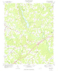
1978 Map of Bunn East
USGS Topo · Published 1978About this map
The Tar River winds across this landscape, dividing the agricultural lands of western Nash and eastern Franklin counties. In the late 1970s, the area's development is centered on small settlements like Bunn and Seven Paths, with the Seaboard Coast Line railroad providing a vital transport corridor for the region. The map captures a transition toward recreational and institutional land use, evidenced by the expansive Lake Sagamore and the presence of the State Correctional Inst near Bunn. Numerous family and community landmarks are documented throughout the rural sections, including Tants Crossroads, Daddysville, and a dense network of country churches such as Rocky Chapel and Holly Grove Ch. The presence of several small streams like Cypress Cr and Biddie Toe Creek suggests a well-watered territory defined by long-standing farming homesteads and small-scale industry like the local Sandpit.
Find a feature on this map
37 named features on this map. Tap any name to fly to it.
Don’t see what you’re looking for? This feature index may not catch every label — zoom into the map to look around manually.
Map Details
Editions of this 1978 Bunn East Map
This is the sole edition of this map. No revisions or reprints were ever made.
Other maps of this area

1902 · Spring Hope
USGS Topo · 1:62,500

1904 · Springhope
USGS Topo · 1:62,500

1953 · Raleigh
USGS Topo · 1:250,000

1953 · Greensboro
USGS Topo · 1:250,000

1954 · Greensboro
USGS Topo · 1:250,000

1954 · Raleigh
USGS Topo · 1:250,000

1962 · Greensboro
USGS Topo · 1:250,000

1966 · Greensboro
USGS Topo · 1:250,000

1968 · Bunn West
USGS Topo · 1:24,000
1968 · Zebulon
USGS Topo · 1:24,000