
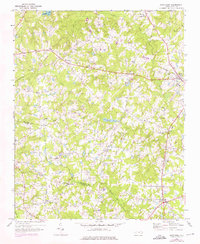
1968 Map of Bunn West
USGS Topo · Published 1972About this map
The rolling agricultural landscape along the Franklin Co Wake Co line is defined by a dense network of small rural settlements and country churches during the late 1960s. The community of Bunn sits at the intersection of local routes and the Seaboard Coast Line railroad, while an Old Railroad Grade further west indicates a shifted transportation corridor from an earlier era. Local life centers on landmarks like Union Gospel Tabernacle, Bethlehem Ch, and Phelps Chapel, alongside the Gethsemane Sch, providing a detailed look at the social geography of the region.
Find a feature on this map
31 named features on this map. Tap any name to fly to it.
Don’t see what you’re looking for? This feature index may not catch every label — zoom into the map to look around manually.
Map Details
Editions of this 1968 Bunn West Map
2 editions found
Other maps of this area

1902 · Spring Hope
USGS Topo · 1:62,500

1904 · Springhope
USGS Topo · 1:62,500

1953 · Raleigh
USGS Topo · 1:250,000

1953 · Greensboro
USGS Topo · 1:250,000

1954 · Greensboro
USGS Topo · 1:250,000

1954 · Raleigh
USGS Topo · 1:250,000

1962 · Greensboro
USGS Topo · 1:250,000

1966 · Greensboro
USGS Topo · 1:250,000

1967 · Knightdale
USGS Topo · 1:24,000
1967 · Rolesville
USGS Topo · 1:24,000