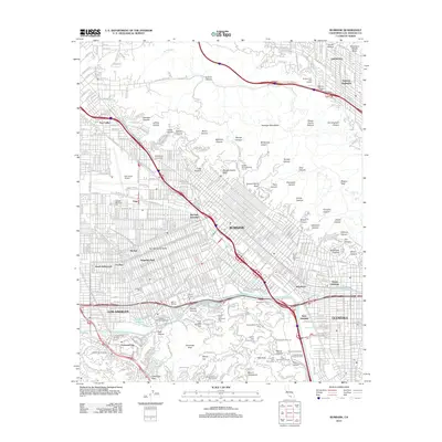
2012 Map of Burbank
USGS Topo · Published 2012About this map
Burbank and the surrounding San Fernando Valley neighborhoods are depicted here at the height of their twentieth-century development. The landscape is defined by its deep ties to the entertainment industry, with the major campuses of Disney Studios, Warner Brothers Studios, and NBC-TV Studios clustered near the Los Angeles River. This map provides a clear view of the urban grid as it meets the southern edge of the Verdugo Mountains, where numerous canyons like Wildwood Canyon and Sunset Canyon transition from residential streets into protected parklands. Notable for genealogists and local historians, the sheet identifies several major interments including Forest Lawn Memorial Park and Valhalla Memorial Park. Significant regional infrastructure, from the Bob Hope Airport to the complex interchanges of I-5 and Ca-134, illustrates the transportation network that connects Universal City and Glendale to the heart of Los Angeles.
Find a feature on this map
90 named features on this map. Tap any name to fly to it.
Don’t see what you’re looking for? This feature index may not catch every label — zoom into the map to look around manually.
Map Details
Editions of this 2012 Burbank Map
This is the sole edition of this map. No revisions or reprints were ever made.
Other maps of this area

1894 · Los Angeles
USGS Topo · 1:62,500

1896 · Pasadena
USGS Topo · 1:62,500

1896 · Santa Monica
USGS Topo · 1:62,500

1898 · Santa Monica
USGS Topo · 1:62,500

1900 · Pasadena
USGS Topo · 1:62,500

1900 · Tujunga
USGS Topo · 1:62,500

1900 · Los Angeles
USGS Topo · 1:62,500

1900 · Fernando
USGS Topo · 1:62,500

1901 · Southern California Sheet No. 1
USGS Topo · 1:250,000

1902 · Santa Monica
USGS Topo · 1:62,500