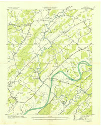
1935 Map of Burem
USGS Topo · Published 1935About this map
The Holston River winds through this 1935 survey of Hawkins County, defining a landscape of narrow ridges and fertile valleys. The rare natural phenomenon of Ebbing and Flowing Springs stands near Amis, while the river itself is anchored by Burem Island and the Burem Bridge. This mid-depression era documentation captures the rural infrastructure of East Tennessee before widespread modernization, shown through the network of local educational and religious centers like Alumwell Academy and Shady Grove Ch.
Find a feature on this map
82 named features on this map. Tap any name to fly to it.
Don’t see what you’re looking for? This feature index may not catch every label — zoom into the map to look around manually.
Map Details
Editions of this 1935 Burem Map
This is the sole edition of this map. No revisions or reprints were ever made.
Other maps of this area

1883 · Morristown
USGS Topo · 1:125,000

1887 · Jonesville
USGS Topo · 1:125,000

1891 · Jonesville
USGS Topo · 1:125,000

1892 · Greeneville
USGS Topo · 1:125,000

1893 · Morristown
USGS Topo · 1:125,000

1894 · Estillville
USGS Topo · 1:125,000

1895 · Morristown
USGS Topo · 1:125,000

1896 · Greeneville
USGS Topo · 1:125,000

1904 · Greeneville
USGS Topo · 1:125,000

1935 · Surgoinsville
USGS Topo · 1:48,000