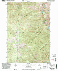
2004 Map of Burgdorf Summit
USGS Topo · Published 2007About this map
The Frank Church River of No Return Wilderness and Payette National Forest meet in this 2004 revision of the Idaho backcountry. The landscape is defined by the steep drainage of the South Fork Salmon River, which marks the eastern boundary. This area reflects a long history of resource extraction and mountain navigation, evidenced by several Prospects and a Mill located near Nelson Point. High-altitude vantage points like Smith Lookout and Smith Knob overlook a network of seasonal routes and saddles, including Sleepy Saddle and Smith Saddle. A remote Landing Strip along the river and the road passing through Burgdorf Summit highlight the essential infrastructure required to access these isolated interior peaks. Further south, Faust Meadows provides a break in the terrain near Mayflower Creek.
Find a feature on this map
24 named features on this map. Tap any name to fly to it.
Don’t see what you’re looking for? This feature index may not catch every label — zoom into the map to look around manually.
Map Details
Editions of this 2004 Burgdorf Summit Map
This is the sole edition of this map. No revisions or reprints were ever made.
Other maps of this area

1937 · Big Creek
USGS Topo · 1:48,000

1942 · Big Creek
USGS Topo · 1:62,500

1956 · Warren
USGS Topo · 1:62,500

1956 · Elk City
USGS Topo · 1:250,000

1960 · Elk City
USGS Topo · 1:250,000

1969 · Pony Meadows
USGS Topo · 1:24,000

1969 · Wolf Fang Peak
USGS Topo · 1:24,000

1969 · Pilot Peak
USGS Topo · 1:24,000

1978 · Chicken Peak
USGS Topo · 1:24,000

1979 · Fivemile Bar
USGS Topo · 1:24,000