1983 Map of Burien
USGS Topo · Published 1983About this map
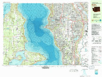
The waters of Puget Sound separate the mainland communities of Burien and Des Moines from the rural character of Vashon Island and Maury Island. This 1983 survey documents a period of significant infrastructure development, most notably the massive footprint of the Seattle-Tacoma International Airport and its impact on surrounding residential areas like McMicken Heights and Sunnydale. On the islands, a more dispersed settlement pattern is visible, with local hubs at Vashon, Burton, and Portage providing social and educational centers such as the Vashon High School and Burton School.
Find a feature on this map
120 named features on this map. Tap any name to fly to it.
Don’t see what you’re looking for? This feature index may not catch every label — zoom into the map to look around manually.
Map Details
Editions of this 1983 Burien Map
This is the sole edition of this map. No revisions or reprints were ever made.
Other maps of this area

1894 · Seattle
USGS Topo · 1:62,500

1895 · Snohomish
USGS Topo · 1:125,000

1897 · Tacoma
USGS Topo · 1:125,000

1897 · Seattle
USGS Topo · 1:125,000

1900 · Tacoma
USGS Topo · 1:125,000

1908 · Seattle
USGS Topo · 1:62,500

1909 · Seattle Special
USGS Topo · 1:62,500

1937 · Port Orchard
USGS Topo · 1:62,500

1942 · Gig Harbor
USGS Topo · 1:62,500

1943 · Gig Harbor
USGS Topo · 1:62,500