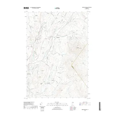
2018 Map of Burke Mountain
USGS Topo · Published 2018About this map
Burke Mountain dominates the eastern horizon of this Vermont landscape, where the East Branch Passumpsic River carves a central valley through the towns of East Burke and Folsom. The settlement pattern reflects a mix of traditional agriculture and more recent recreation, with numerous named trails like Troll Stroll and Coronary Bypass indicating the area's development for outdoor activities. Historic infrastructure remains visible in landmarks such as the Burrington Covered Bridge near East Lyndon. Genealogy researchers can locate several well-preserved burial grounds, including Howland Cemetery and the North Kirby Brookside Cemetery. To the west, the West Burke Aerodrome sits near the headwaters of Roundy Brook, while the village of Lyndonville occupies the southwestern corner of the quadrangle. The map captures a transition where old farm roads like White School Road meet modern recreational development along the slopes of Kirby Mountain.
Find a feature on this map
128 named features on this map. Tap any name to fly to it.
Don’t see what you’re looking for? This feature index may not catch every label — zoom into the map to look around manually.
Map Details
Editions of this 2018 Burke Mountain Map
This is the sole edition of this map. No revisions or reprints were ever made.
Other maps of this area

1931 · Littleton
USGS Topo · 1:62,500

1932 · Littleton
USGS Topo · 1:48,000

1935 · Littleton
USGS Topo · 1:62,500

1935 · Lyndonville
USGS Topo · 1:48,000

1938 · St. Johnsbury
USGS Topo · 1:48,000

1939 · Lyndonville
USGS Topo · 1:62,500

1943 · St. Johnsbury
USGS Topo · 1:62,500
1949 · St. Johnsbury
USGS Topo · 1:62,500

1950 · Lake Champlain
USGS Topo · 1:250,000

1950 · Lewiston
USGS Topo · 1:250,000