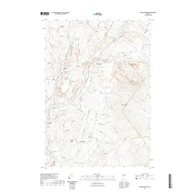
2021 Map of Burke Mountain
USGS Topo · Published 2021About this map
Burke Mtn and its West Peak dominate this Northeast Kingdom landscape, where the East Branch Passumpsic River carves a valley between high granite ridges. The settlement pattern follows the water and the roads that hug the terrain, with East Burke and Lyndonville serving as primary hubs. Local history is etched into the hillsides through numerous small burial grounds like Woodmont Cem and Burke Green Cem, while the Burrington Covered Bridge spans the river at East Lyndon, marking a traditional crossing point that has endured into the modern era.
Find a feature on this map
128 named features on this map. Tap any name to fly to it.
Don’t see what you’re looking for? This feature index may not catch every label — zoom into the map to look around manually.
Map Details
Editions of this 2021 Burke Mountain Map
This is the sole edition of this map. No revisions or reprints were ever made.
Other maps of this area

1931 · Littleton
USGS Topo · 1:62,500

1932 · Littleton
USGS Topo · 1:48,000

1935 · Littleton
USGS Topo · 1:62,500

1935 · Lyndonville
USGS Topo · 1:48,000

1938 · St. Johnsbury
USGS Topo · 1:48,000

1939 · Lyndonville
USGS Topo · 1:62,500

1943 · St. Johnsbury
USGS Topo · 1:62,500
1949 · St. Johnsbury
USGS Topo · 1:62,500

1950 · Lake Champlain
USGS Topo · 1:250,000

1950 · Lewiston
USGS Topo · 1:250,000