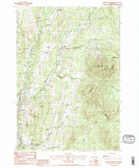
1988 Map of Burke Mountain
USGS Topo · Published 1988About this map
Burke Mtn dominates the eastern skyline of this late 1980s topographical survey, a prominent landmark equipped with a Radio Tower (Fire Tower) and surrounded by the expansive Darling State Forest Park. The landscape transitions from these steep wooded heights into the valley settlements of East Burke and Lyndonville, where the drainage of the West Branch and East Branch converge. To the south and west, the terrain is marked by smaller family-named rises such as Bemis Hill, Shonya Hill, and Pudding Hill.
Find a feature on this map
46 named features on this map. Tap any name to fly to it.
Don’t see what you’re looking for? This feature index may not catch every label — zoom into the map to look around manually.
Map Details
Editions of this 1988 Burke Mountain Map
2 editions found
Other maps of this area

1931 · Littleton
USGS Topo · 1:62,500

1932 · Littleton
USGS Topo · 1:48,000

1935 · Littleton
USGS Topo · 1:62,500

1935 · Lyndonville
USGS Topo · 1:48,000

1938 · St. Johnsbury
USGS Topo · 1:48,000

1939 · Lyndonville
USGS Topo · 1:62,500

1943 · St. Johnsbury
USGS Topo · 1:62,500
1949 · St. Johnsbury
USGS Topo · 1:62,500

1950 · Lake Champlain
USGS Topo · 1:250,000

1950 · Lewiston
USGS Topo · 1:250,000