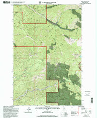
1996 Map of Burke
USGS Topo · Published 1999About this map
Canyon Creek carves a deep industrial path through the heart of the Bitterroot Mountains, defining the landscape of this Idaho-Montana border region. The canyon floor is a continuous string of mining settlements and operations, from Black Bear and Gem in the west through Mace to Burke. The density of extraction is evident in the numerous Adits and extensive Tailings that flank the valley walls. Significant deep-rock operations such as the Standard Mammoth Mine, Hecla Mine, and Tiger Poorman Mine illustrate the intense silver and lead mining legacy of the Coeur d'Alene district. Higher elevations are dominated by peaks like Tiger Peak and Custer Peak, while the northern portion of the map shows the transition toward Prichard Creek and the Golden Chest Mine. The map reveals a complex network of 4wd tracks and forest roads serving the Coeur d'Alene National Forest.
Find a feature on this map
77 named features on this map. Tap any name to fly to it.
Don’t see what you’re looking for? This feature index may not catch every label — zoom into the map to look around manually.
Map Details
Editions of this 1996 Burke Map
This is the sole edition of this map. No revisions or reprints were ever made.
Other maps of this area

1901 · Coeur D'Alene District
USGS Topo · 1:62,500

1903 · Coeur D'Alene District
USGS Topo · 1:62,500

1906 · Coeur D'Alene District
USGS Topo · 1:62,500

1914 · Avery
USGS Topo · 1:125,000

1917 · Avery
USGS Topo · 1:125,000

1932 · Trout Creek
USGS Topo · 1:125,000

1935 · Trout Creek
USGS Topo · 1:125,000

1936 · Trout Creek
USGS Topo · 1:125,000

1956 · Cooper Gulch
USGS Topo · 1:62,500

1956 · Saltese
USGS Topo · 1:62,500