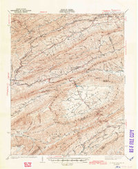
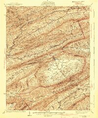
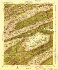
1941 Map of Burkes Garden
USGS Topo · Published 1944About this map
The unique geological bowl of Burkes Garden dominates this landscape, surrounded by the high peaks of Garden Mountain. This natural basin, often called God's Thumbprint, shows a concentrated pattern of rural life in the 1930s, featuring Concord Ch and Central Ridge amidst numerous springs like Blue Spring. Beyond the basin, the map traces the Ohio Watershed Tennessee Divide, a critical drainage boundary separating the waters flowing toward the Bluestone River and the South Fork Holston River.
Find a feature on this map
109 named features on this map. Tap any name to fly to it.
Don’t see what you’re looking for? This feature index may not catch every label — zoom into the map to look around manually.
Map Details
Editions of this 1941 Burkes Garden Map
3 editions found
Other maps of this area

1887 · Pocahontas
USGS Topo · 1:125,000

1889 · Wytheville
USGS Topo · 1:125,000

1891 · Tazewell
USGS Topo · 1:125,000

1891 · Pocahontas
USGS Topo · 1:125,000

1891 · Abingdon
USGS Topo · 1:125,000

1892 · Wytheville
USGS Topo · 1:125,000

1894 · Pocahontas
USGS Topo · 1:125,000

1894 · Abingdon
USGS Topo · 1:125,000

1895 · Tazewell
USGS Topo · 1:125,000

1895 · Pocahontas
USGS Topo · 1:125,000