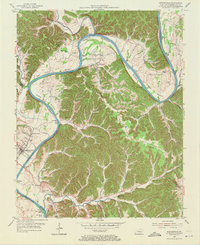
1953 Map of Burkesville
USGS Topo · Published 1971About this map
The Cumberland River carves a winding path through this region of southern Kentucky, defining the lives and livelihoods of those in Burkesville and its surrounding river bottoms. During the early 1950s, the river remained a vital transit corridor, evidenced by Garman Ferry and Scotts Ferry, which provided essential crossings before modern bridges dominated the landscape. The geography is characterized by fertile lowlands like Howards Bottom and Scotts Bottom, contrasted with the high ground of String Ridge and Smith Grove Ridge. Small rural settlements and educational hubs such as Dougan Town, Bakerton, and the Seminary Sch are scattered throughout the hills, while numerous Oil Wells indicate the era's local extraction industry. This survey documents a traditional river-valley economy shortly before shifting transportation patterns and agricultural changes altered these tight-knit Cumberland communities.
Find a feature on this map
66 named features on this map. Tap any name to fly to it.
Don’t see what you’re looking for? This feature index may not catch every label — zoom into the map to look around manually.
Map Details
Editions of this 1953 Burkesville Map
2 editions found
Other maps of this area

1924 · Lillydale
USGS Topo · 1:62,500

1926 · Lillydale
USGS Topo · 1:62,500

1929 · Lillydale
USGS Topo · 1:62,500

1929 · Byrdstown
USGS Topo · 1:62,500

1953 · Breeding
USGS Topo · 1:24,000

1953 · Waterview
USGS Topo · 1:24,000

1953 · Amandaville
USGS Topo · 1:24,000

1953 · Burkesville
USGS Topo · 1:24,000

1953 · Wolf Creek Dam
USGS Topo · 1:24,000

1953 · Creelsboro
USGS Topo · 1:24,000