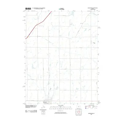
2009 Map of Burlingame
USGS Topo · Published 2009About this map
Burlingame serves as the focal point of this Osage County landscape, situated at the junction of key transit corridors and surrounded by a network of drainage systems essential to the region's agricultural character. The terrain is defined by the winding paths of the Wakarusa River and its South Branch, which carve through the northern sections of the quadrangle. To the south and east, the hydrology shifts toward the Hundred and Ten Mile Creek and Switzler Creek basins. This 2009 survey highlights a structured grid of rural roads, including S Burlingame Rd and S Auburn RD, which connect scattered farmsteads and agricultural plots. Notable landmarks such as Stenger Hill provide topographic relief against the primarily low-lying drainage areas like Major Draw, illustrating the relationship between the prairie elevation and the watercourses that have shaped local land use for generations.
Find a feature on this map
29 named features on this map. Tap any name to fly to it.
Don’t see what you’re looking for? This feature index may not catch every label — zoom into the map to look around manually.
Map Details
Editions of this 2009 Burlingame Map
This is the sole edition of this map. No revisions or reprints were ever made.
Other maps of this area

1889 · Burlingame
USGS Topo · 1:125,000

1894 · Burlingame
USGS Topo · 1:125,000

1947 · Lawrence
USGS Topo · 1:250,000

1950 · Lawrence
USGS Topo · 1:250,000

1952 · Auburn
USGS Topo · 1:24,000

1952 · Harveyville
USGS Topo · 1:24,000
1952 · Dover
USGS Topo · 1:24,000

1952 · Burlingame
USGS Topo · 1:24,000
1955 · Wakarusa
USGS Topo · 1:24,000

1955 · Carbondale
USGS Topo · 1:24,000