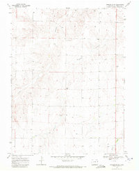
1969 Map of Burlington NE
USGS Topo · Published 1972About this map
Landsman Creek and Bonny Creek carve a series of subtle drainages across this high plains landscape of Kit Carson County, just prior to the turn of the 1970s. The map illustrates a rural environment defined by its agricultural layout and resource management, evidenced by numerous wells scattered across the township grid. A notable local landmark, the Emerson School, sits centrally within this landscape, serving as a social and educational anchor for the surrounding farmsteads. To the east, the Kansas State Line marks the jurisdictional boundary, where the prairie begins its transition into the neighboring state. Small-scale industrial activity is present in the form of several Gravel Pits, often situated near the creek beds where alluvial deposits provided necessary materials for local road improvements.
Find a feature on this map
7 named features on this map. Tap any name to fly to it.
Don’t see what you’re looking for? This feature index may not catch every label — zoom into the map to look around manually.
Map Details
Editions of this 1969 Burlington NE Map
This is the sole edition of this map. No revisions or reprints were ever made.
Other maps of this area

1950 · Bonny Reservoir
USGS Topo · 1:62,500

1954 · Limon
USGS Topo · 1:250,000

1957 · Limon
USGS Topo · 1:250,000

1958 · Limon
USGS Topo · 1:250,000

1969 · Settlement
USGS Topo · 1:24,000

1969 · Bethune
USGS Topo · 1:24,000

1969 · Burlington
USGS Topo · 1:24,000

1969 · Idalia SE
USGS Topo · 1:24,000

1969 · Idalia SW
USGS Topo · 1:24,000

1969 · Peconic
USGS Topo · 1:24,000