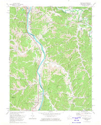
1972 Map of Burnaugh
USGS Topo · Published 1974About this map
The Big Sandy River forms a critical corridor along the state line between Kentucky and West Virginia in the early 1970s. Industrial and transit networks dominate the riverbank, where the Norfolk and Western and Chesapeake and Ohio railroads track the water's edge near Burnaugh and Neal. Above the floodplain, the Tri-State Airport occupies the high ground north of Dock Creek. The interior is defined by deep hollows and family-named landmarks, including the Lockwood Cem and Whites Creek Ch. Traces of the region's energy and infrastructure economy are visible through numerous labels for Pipeline segments and Mines that pepper the creek branches. This survey provides a record of the area's rural transition, showing the density of small communities like Kavanaugh and Cyrus before significant modern development altered these traditional valley settlements.
Find a feature on this map
58 named features on this map. Tap any name to fly to it.
Don’t see what you’re looking for? This feature index may not catch every label — zoom into the map to look around manually.
Map Details
Editions of this 1972 Burnaugh Map
3 editions found
Other maps of this area

1892 · Huntington
USGS Topo · 1:125,000

1898 · Huntington
USGS Topo · 1:125,000

1901 · Guyandot
USGS Topo · 1:62,500

1901 · Ceredo
USGS Topo · 1:62,500

1902 · Guyandot
USGS Topo · 1:62,500

1903 · Kenova
USGS Topo · 1:125,000

1904 · Kenova
USGS Topo · 1:125,000

1909 · Wayne
USGS Topo · 1:62,500

1911 · Louisa
USGS Topo · 1:48,000

1913 · Ceredo
USGS Topo · 1:62,500