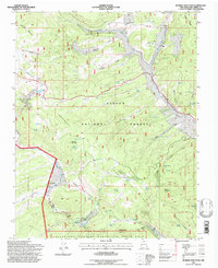
1995 Map of Burned Mountain
USGS Topo · Published 1997About this map
Tusas Mountain and the high ridges of the Carson National Forest dominate this mid-1990s survey of Rio Arriba County. The landscape is defined by its water sources and ranching history, where the headwaters of the Rio Tusas and Rio Vallecitos flow through canyons marked by numerous stock tanks like Loyd Tank and Amos Tank. Traces of earlier resource extraction appear in several labeled mines and prospects near Hopewell Lake, suggesting the area's mineral interests.
Find a feature on this map
62 named features on this map. Tap any name to fly to it.
Don’t see what you’re looking for? This feature index may not catch every label — zoom into the map to look around manually.
Map Details
Editions of this 1995 Burned Mountain Map
This is the sole edition of this map. No revisions or reprints were ever made.
Other maps of this area

1918 · Tusas
USGS Topo · 1:125,000

1954 · Aztec
USGS Topo · 1:250,000

1955 · Cebolla
USGS Topo · 1:62,500

1955 · Brazos Peak
USGS Topo · 1:62,500

1958 · Aztec
USGS Topo · 1:250,000

1962 · Aztec
USGS Topo · 1:250,000
1963 · Las Tablas
USGS Topo · 1:24,000

1963 · Broke Off Mountain
USGS Topo · 1:24,000

1963 · Burned Mountain
USGS Topo · 1:24,000
1963 · San Antonio Mountain
USGS Topo · 1:24,000