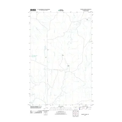
2011 Map of Burnett Creek
USGS Topo · Published 2011About this map
Burnett Creek and its tributaries define the drainage patterns of this Valley County landscape, illustrating a remote region of Montana shaped by water management and livestock ranching. The presence of irrigation infrastructure like Corral Dam and Collins Dam highlights the necessity of water storage in this semi-arid environment. These smaller reservoirs, including the notable Desert Claim Reservoir, provide essential resources for local operations connected by thoroughfares such as Rock Creek Rd and Hinsdale Livestock Rd. The terrain is further marked by distinct geological depressions like Badland Coulee and Cow Coulee, which channel seasonal runoff toward larger systems like Willow Creek and Chisholm Creek. This 2011 survey serves as a record of the rural infrastructure and natural drainage networks that support the ranching economy in northern Montana.
Find a feature on this map
18 named features on this map. Tap any name to fly to it.
Don’t see what you’re looking for? This feature index may not catch every label — zoom into the map to look around manually.
Map Details
Editions of this 2011 Burnett Creek Map
This is the sole edition of this map. No revisions or reprints were ever made.
Other maps of this area

1919 · Boundary
USGS Topo · 1:125,000

1954 · Glasgow
USGS Topo · 1:250,000

1957 · Glasgow
USGS Topo · 1:250,000

1958 · Glasgow
USGS Topo · 1:250,000

1984 · Laundry Hill
USGS Topo · 1:24,000

1984 · Snake Creek School
USGS Topo · 1:24,000

1984 · Opheim
USGS Topo · 1:100,000
1984 · Jones Coulee
USGS Topo · 1:24,000

1984 · Gay Dam
USGS Topo · 1:24,000

1984 · Last Chance Reservoir
USGS Topo · 1:24,000