
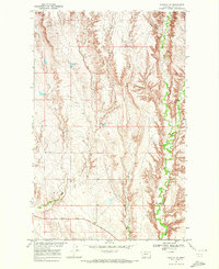
1984 Map of Laundry Hill
USGS Topo · Published 1984About this map
Laundry Hill and the high plains of Newberry Flat define this landscape in north-central Montana, where water management is central to the local geography. The map reveals a sophisticated network of small-scale irrigation and stock water sources, including Trapper Reservoir, Mail Reservoir, and Newberry Flat Reservoir. These features, alongside named springs such as Laundry Spring and Kummerfort Spring, indicate the vital importance of reliable water for ranching and homesteading in the Missouri River drainage basin. The intricate drainage patterns of Eagle Creek, Lime Creek, and Bear Creek cut through the terrain, illustrating the seasonal flow and erosion that shape this part of Valley County. For those tracing regional land use, the placement of family-named water features like Ada Reservoir and Anna Reservoir offers clues to early 20th-century settlement patterns in this prairie environment.
Find a feature on this map
19 named features on this map. Tap any name to fly to it.
Don’t see what you’re looking for? This feature index may not catch every label — zoom into the map to look around manually.
Map Details
Editions of this 1984 Laundry Hill Map
This is the sole edition of this map. No revisions or reprints were ever made.
Other maps of this area

1919 · Boundary
USGS Topo · 1:125,000

1943 · Glasgow
USGS Topo · 1:125,000

1954 · Glasgow
USGS Topo · 1:250,000

1957 · Glasgow
USGS Topo · 1:250,000

1958 · Glasgow
USGS Topo · 1:250,000

1969 · Cornwell Reservoir
USGS Topo · 1:24,000
1969 · Tampico NE
USGS Topo · 1:24,000

1969 · Ellsworth Coulee
USGS Topo · 1:24,000

1984 · Opheim
USGS Topo · 1:100,000

1984 · Gay Dam
USGS Topo · 1:24,000