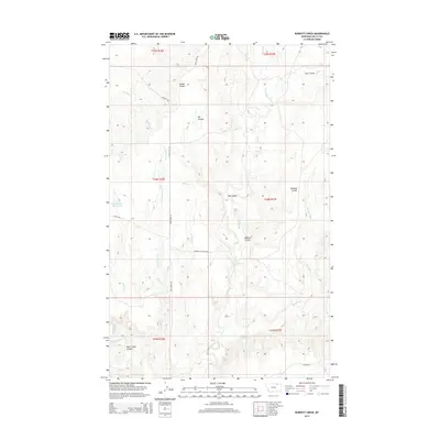
2014 Map of Burnett Creek
USGS Topo · Published 2014About this map
Rock Creek Canyon anchors the southwestern reaches of this Valley County landscape, where the deeply carved drainages of the Missouri River watershed define the terrain. The map captures an era of ranching and remote infrastructure in the early 21st century, centered on the confluence of several prominent coulees including Big Coulee and Badland Coulee. Human activity is primarily traced through specialized access routes like the Hinsdale Livestock Rd and Rock Creek Rd, which navigate the high benches between watercourses. Water management in this arid environment is evidenced by the Desert Claim Reservoir in the west. The drainage network is complex, with Willow Cr and Burnett Cr cutting through the central sections, while the headwaters of Chisholm Cr and W Fork Bitter Cr mark the eastern and southern boundaries.
Find a feature on this map
26 named features on this map. Tap any name to fly to it.
Don’t see what you’re looking for? This feature index may not catch every label — zoom into the map to look around manually.
Map Details
Editions of this 2014 Burnett Creek Map
This is the sole edition of this map. No revisions or reprints were ever made.
Other maps of this area

1919 · Boundary
USGS Topo · 1:125,000

1954 · Glasgow
USGS Topo · 1:250,000

1957 · Glasgow
USGS Topo · 1:250,000

1958 · Glasgow
USGS Topo · 1:250,000

1984 · Laundry Hill
USGS Topo · 1:24,000

1984 · Snake Creek School
USGS Topo · 1:24,000

1984 · Opheim
USGS Topo · 1:100,000
1984 · Jones Coulee
USGS Topo · 1:24,000

1984 · Gay Dam
USGS Topo · 1:24,000

1984 · Last Chance Reservoir
USGS Topo · 1:24,000