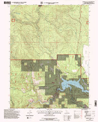
1995 Map of Burney Falls
USGS Topo · Published 1998About this map
Lake Britton and the Pit River dominate this pocket of the southern Cascades, where hydroelectric infrastructure and recreation meet. The landscape is defined by the Pit No 3 Dam and the surrounding Shasta National Forest, which includes the landmark Mc Arthur-Burney Falls Memorial State Park. Long-standing settlement patterns are visible at Cayton and the nearby Cayton Siding, while outdoor life is represented by Clark Creek Lodge and Camp Shasta. For those tracing local heritage, the map identifies the Britton Cem and Pioneer Cem near the reservoir. The Pacific Crest National Scenic Trail winds through the varied terrain of Delucca Ridge and Bird Flat, following the transition from deep river canyons to the high timbered slopes of the national forest boundary.
Find a feature on this map
39 named features on this map. Tap any name to fly to it.
Don’t see what you’re looking for? This feature index may not catch every label — zoom into the map to look around manually.
Map Details
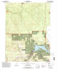
Editions of this 1995 Burney Falls Map
2 editions found
Other maps of this area

1886 · Lassen Peak
USGS Topo · 1:250,000

1886 · Modoc Lava Bed
USGS Topo · 1:250,000

1892 · Modoc Lava-Bed
USGS Topo · 1:250,000

1892 · Lassen Peak
USGS Topo · 1:250,000

1894 · Lassen Peak
USGS Topo · 1:250,000

1932 · Bartle
USGS Topo · 1:96,000

1935 · Burney
USGS Topo · 1:96,000

1939 · Burney
USGS Topo · 1:125,000

1939 · Bartle
USGS Topo · 1:125,000

1954 · Alturas
USGS Topo · 1:250,000