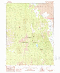
1990 Map of Burney Mountain East
USGS Topo · Published 1990About this map
Lassen National Forest terrain dominates this 1990 survey, where the volcanic character of the California landscape is revealed through an array of lava flows and cinder features. The eastern edge of the map is defined by the Hat Creek Valley, a vital corridor for travel and settlement that includes the Hat Creek FS Station and organized campgrounds. The complex topography is punctuated by numerous volcanic landforms such as Burney Mountain, Cinder Butte, and the Twin Buttes. Water sources like Cornaz Lake, Cornaz Spring, and Burney Spring indicate the crucial locations for hydration in this porous geological environment. The presence of several Cinder Pits suggests local extractive industry, while a network of 4wd tracks provides access through the timber and lava fields.
Find a feature on this map
24 named features on this map. Tap any name to fly to it.
Don’t see what you’re looking for? This feature index may not catch every label — zoom into the map to look around manually.
Map Details
Editions of this 1990 Burney Mountain East Map
This is the sole edition of this map. No revisions or reprints were ever made.
Other maps of this area

1886 · Lassen Peak
USGS Topo · 1:250,000

1892 · Lassen Peak
USGS Topo · 1:250,000

1894 · Lassen Peak
USGS Topo · 1:250,000

1935 · Burney
USGS Topo · 1:96,000

1939 · Burney
USGS Topo · 1:125,000

1939 · Halls Flat
USGS Topo · 1:125,000

1955 · Westwood
USGS Topo · 1:250,000

1956 · Manzanita Lake
USGS Topo · 1:62,500

1957 · Prospect Peak
USGS Topo · 1:62,500

1957 · Burney
USGS Topo · 1:62,500