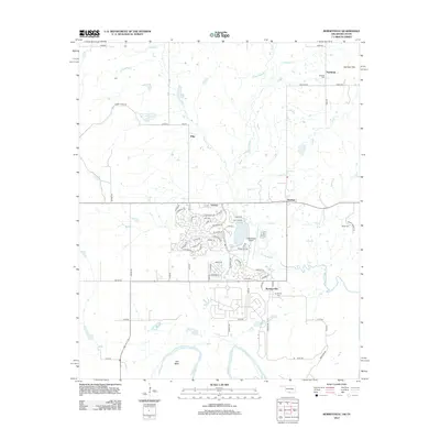
2013 Map of Burneyville
USGS Topo · Published 2013About this map
Walnut Bayou and Red River define the winding hydrology of this Love County landscape, where the rural settlements of Burneyville and Turner anchor a network of local roads. The terrain transitions from the elevations of Eastman Hills in the northeast to the broad alluvial plain at Tyas Bend in the south. Aviation and leisure interests are represented by the presence of Falconhead Airport and its surrounding residential loop roads, including Laramie Dr and Chisholm Trl. Genealogists will find several burial grounds across the quadrangle, such as Eastman Cem, Box Cem, Parker Cem, and the namesake Burneyville Cem. Smaller watercourses including Simon Cr, Cherokee Cr, Dry Cr, and Bone Cr drain the ranch lands, feeding into the larger river system that forms the southern boundary of the region.
Find a feature on this map
73 named features on this map. Tap any name to fly to it.
Don’t see what you’re looking for? This feature index may not catch every label — zoom into the map to look around manually.
Map Details
Editions of this 2013 Burneyville Map
This is the sole edition of this map. No revisions or reprints were ever made.
Other maps of this area

1901 · Ardmore
USGS Topo · 1:125,000

1902 · Gainesville
USGS Topo · 1:125,000

1918 · Ardmore
USGS Topo · 1:125,000

1943 · Gainesville
USGS Topo · 1:125,000

1954 · Sherman
USGS Topo · 1:250,000

1957 · Ardmore
USGS Topo · 1:250,000

1958 · Sherman
USGS Topo · 1:250,000

1963 · Ardmore
USGS Topo · 1:250,000

1964 · Overbrook
USGS Topo · 1:24,000
1968 · Thackerville
USGS Topo · 1:24,000