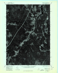
1975 Map of Burnham NW
USGS Topo · Published 1980About this map
The Sebasticook River winds through the heart of this mid-1970s orthophotoquad, serving as the central geographic feature of the Waldo County landscape. This aerial perspective, captured in late October, reveals a patchwork of agricultural clearings and dense woodland that surrounds the central settlement of Burnham. The imagery provides a clear view of the village layout and its relationship to the water, while the neighboring settlements of Winnecook, Dix Corner, and Clinton anchor the surrounding rural tracts. Unlike traditional line maps, this photographic record shows the actual density of forest cover and the precise geometry of fields and roads during this era, offering a literal view of the land before modern expansion or forest succession altered these historic farmsteads and riverside properties.
Find a feature on this map
5 named features on this map. Tap any name to fly to it.
Don’t see what you’re looking for? This feature index may not catch every label — zoom into the map to look around manually.
Map Details
Editions of this 1975 Burnham NW Map
This is the sole edition of this map. No revisions or reprints were ever made.
Other maps of this area

1892 · Waterville
USGS Topo · 1:62,500

1913 · Skowhegan
USGS Topo · 1:62,500

1926 · Burnham
USGS Topo · 1:62,500

1930 · Pittsfield
USGS Topo · 1:48,000

1932 · Pittsfield
USGS Topo · 1:62,500

1933 · Pittsfield
USGS Topo · 1:62,500

1943 · Waterville
USGS Topo · 1:62,500

1948 · Bangor
USGS Topo · 1:250,000

1955 · Pittsfield
USGS Topo · 1:62,500

1955 · Skowhegan
USGS Topo · 1:62,500