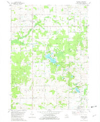
1981 Map of Burnips
USGS Topo · Published 1982About this map
Burnips stands at the center of this rural landscape, which is defined by an active industrial and agricultural mix. The area north of the Little Rabbit River is heavily dotted with infrastructure from the Oil and Gas Field, including numerous Oil Wells and a Powerplant. The terrain transitions from these industrial pockets in Salem to the lake-strewn lands of Monterey to the south. Numerous local institutions are mapped, including the Indian Mission and the Market Street Ch, alongside rural schoolhouses like Sycamore Sch.
Find a feature on this map
61 named features on this map. Tap any name to fly to it.
Don’t see what you’re looking for? This feature index may not catch every label — zoom into the map to look around manually.
Map Details
Editions of this 1981 Burnips Map
This is the sole edition of this map. No revisions or reprints were ever made.
Other maps of this area

1914 · Grand Rapids
USGS Topo · 1:62,500

1943 · Grand Rapids
USGS Topo · 1:62,500

1958 · Allegan
USGS Topo · 1:62,500

1958 · Grandville
USGS Topo · 1:62,500

1958 · Grand Rapids
USGS Topo · 1:250,000

1959 · Wayland
USGS Topo · 1:62,500

1961 · Grand Rapids
USGS Topo · 1:250,000

1962 · Grand Rapids
USGS Topo · 1:250,000
1967 · Cutlerville
USGS Topo · 1:24,000
1980 · Hudsonville West
USGS Topo · 1:24,000