
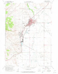
1960 Map of Burns
USGS Topo · Published 1962About this map
The Burns and Hines municipal centers define this High Desert landscape in the early 1960s, showing a well-established grid of streets like Adams St and Washington St alongside civic mainstays including the Courthouse and Hospital. The area is a critical junction for regional transport and agriculture, where the Oregon and Northwestern and Pacific Union railroads converge near the industrial Gravel Pits and the expansive Burns Indian Reservation. Outside the concentrated red-tinted urban blocks, the terrain gives way to the complex hydrology of the Silvies River and its numerous branches, such as Foley Slough and Newman Slough. Local landmarks like the Oregon Agricultural Experimental Sta and the County Fairgrounds highlight the community's reliance on the surrounding valley floor, while the Burns Piute Cem and Burns Cem provide essential locations for genealogical research in Harney County.
Find a feature on this map
53 named features on this map. Tap any name to fly to it.
Don’t see what you’re looking for? This feature index may not catch every label — zoom into the map to look around manually.
Map Details
Editions of this 1960 Burns Map
2 editions found
Other maps of this area

1955 · Burns
USGS Topo · 1:250,000

1958 · Burns
USGS Topo · 1:250,000

1959 · Burns
USGS Topo · 1:250,000

1959 · Harney
USGS Topo · 1:62,500

1959 · Dog Mountain
USGS Topo · 1:62,500

1959 · Lawen
USGS Topo · 1:62,500

1960 · Burns
USGS Topo · 1:62,500

1975 · Burns
USGS Topo · 1:24,000

1978 · Malheur Lake
USGS Topo · 1:100,000

1978 · Stinkingwater Mountains
USGS Topo · 1:100,000