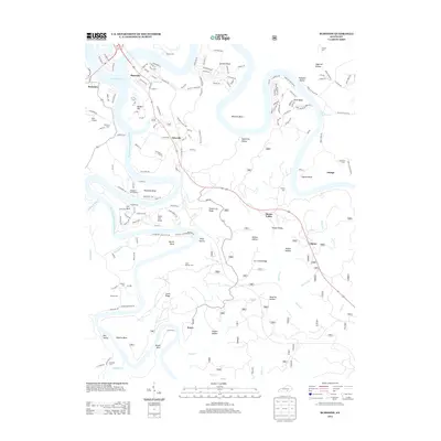
2013 Map of Burnside
USGS Topo · Published 2013About this map
Lake Cumberland and the Big S Fork Cumberland River dominate this terrain, carving a series of dramatic bends and hollows into the Pulaski County landscape. The town of Burnside sits at the northern edge, where the reservoir expands, while smaller settlements like Tateville, Sloans Valley, and Alpine follow the corridor of Highway 27 to the south. The map documents a landscape defined by its complex topography, where named features like Sweet Lily Ridge and Seed Tick Knob rise above deep drainage systems like McKee Hollow and Dead Ox Hollow. For the local historian, the map preserves the locations of numerous family and community burial grounds, including Cave Springs Cem, Hollers Cem, and Gibson Cem. The presence of the Woodson Bend Resort and Bóss Airport reflects the area's development as a destination for recreation and transport amidst the natural ridges of the Cumberland plateau.
Find a feature on this map
163 named features on this map. Tap any name to fly to it.
Don’t see what you’re looking for? This feature index may not catch every label — zoom into the map to look around manually.
Map Details
Editions of this 2013 Burnside Map
This is the sole edition of this map. No revisions or reprints were ever made.
Other maps of this area

1890 · Williamsburg
USGS Topo · 1:125,000

1893 · London
USGS Topo · 1:125,000

1894 · Williamsburg
USGS Topo · 1:125,000

1897 · London
USGS Topo · 1:125,000

1932 · Burnside
USGS Topo · 1:62,500

1935 · Somerset
USGS Topo · 1:62,500

1952 · Hail
USGS Topo · 1:24,000

1952 · Wiborg
USGS Topo · 1:24,000

1952 · Dykes
USGS Topo · 1:24,000

1953 · Frazer
USGS Topo · 1:24,000