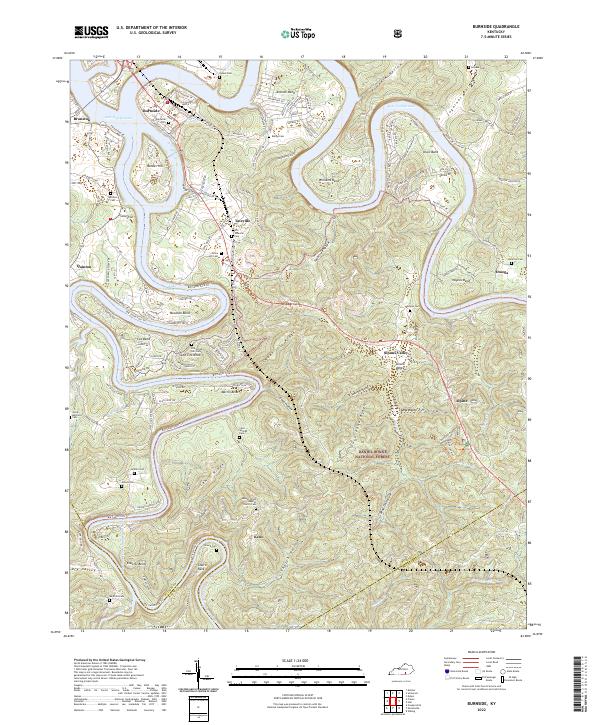
2022 Map of Burnside
USGS Topo · Published 2022About this map
Burnside sits at the northern edge of this map where the Big South Fork Cumberland River meets the expansive waters of Lake Cumberland. The landscape is defined by dramatic river bends including Antioch Bend, Williams Bend, and Roberts Bend, which carve through the dense timber of the Daniel Boone National Forest. These river loops created isolated plateaus and ridges like Lewis Ridge and Sweet Lily Ridge, where smaller communities such as Tateville, Keno, and Sloans Valley are established. Local history is deeply embedded in the terrain, evidenced by numerous family and community burial sites such as the Old Tateville Cem, Jacob Mayfield Cem, and Old Grave Hill Cem. The southern portion of the sheet shows the transition from Pulaski County into McCreary and Wayne Counties, with the winding Big South Fork Trl following the rugged watercourse.
Find a feature on this map
67 named features on this map. Tap any name to fly to it.
Don’t see what you’re looking for? This feature index may not catch every label — zoom into the map to look around manually.
Map Details
Editions of this 2022 Burnside Map
This is the sole edition of this map. No revisions or reprints were ever made.
Historical Maps of Tateville Through Time
4 maps found