1998 Map of Burnsville
USGS Topo · Published 2001About this map
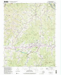
The Cane River corridor defines the valley floor of this Yancey County landscape, where the town of Burnsville serves as a central hub beneath the towering Cane River Mountains. This late-twentieth-century survey, based on 1939 topography, illustrates a community deeply rooted in its geography, with numerous small settlements like Day Book, Green Mountain, and Windom following the paths of the many branches and forks. Educational and religious heritage is prominent, from Mine Fork Sch and Baker Creek Sch to churches like Bowring Chapel and Zion Ch. Much of the southern and eastern terrain is preserved as part of the Pisgah National Forest and Pisgah Game Lands, where landmarks like Beebranch Mtn and Bowlens Pyramid rise sharply above the State Prison Camp and the Mt Mitchell Boys Camp along the river.
Find a feature on this map
130 named features on this map. Tap any name to fly to it.
Don’t see what you’re looking for? This feature index may not catch every label — zoom into the map to look around manually.
Map Details
Editions of this 1998 Burnsville Map
This is the sole edition of this map. No revisions or reprints were ever made.
Other maps of this area

1891 · Roan Mountain
USGS Topo · 1:125,000

1894 · Roan Mountain
USGS Topo · 1:125,000

1900 · Mount Mitchell
USGS Topo · 1:125,000

1902 · Mount Mitchell
USGS Topo · 1:125,000

1904 · Roan Mountain
USGS Topo · 1:125,000

1934 · Micaville
USGS Topo · 1:24,000

1934 · Parts Of Celo And Black Brothers
USGS Topo · 1:24,000

1934 · Bakersville
USGS Topo · 1:24,000

1935 · Black Brothers
USGS Topo · 1:24,000

1935 · Chestoa
USGS Topo · 1:24,000