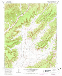
1967 Map of Burnt Corn Spring
USGS Topo · Published 1983About this map
Burnt Corn Valley serves as the central corridor of this survey, deeply etched into the Navajo Indian Reservation landscape during the mid-1960s. The map documents a high-desert environment where water sources define the geography of the land, specifically highlighting remote locations like Burnt Corn Spring, Pine Spring, and Salt Water Spring. These points of reliable water are critical landmarks in a region defined by seasonal drainages such as Burnt Corn Wash and Wepo Wash.
Find a feature on this map
17 named features on this map. Tap any name to fly to it.
Don’t see what you’re looking for? This feature index may not catch every label — zoom into the map to look around manually.
Map Details
Editions of this 1967 Burnt Corn Spring Map
2 editions found
Other maps of this area

1883 · Marsh Pass
USGS Topo · 1:250,000

1892 · Marsh Pass
USGS Topo · 1:250,000

1892 · Canyon De Chelly
USGS Topo · 1:250,000

1954 · Shiprock
USGS Topo · 1:250,000

1956 · Marble Canyon
USGS Topo · 1:250,000

1958 · Shiprock
USGS Topo · 1:250,000

1959 · Shiprock
USGS Topo · 1:250,000

1959 · Marble Canyon
USGS Topo · 1:250,000

1961 · Marble Canyon
USGS Topo · 1:250,000
1967 · Whippoorwill Spring
USGS Topo · 1:24,000