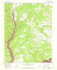
1954 Map of Burnt Mesa
USGS Topo · Published 1973About this map
The Los Pinos River corridor defines this northern New Mexico landscape, shown here as it transitioned during the mid-20th century. The arrival of the Navajo Reservoir is the central geographical shift, with purple photorevisions from 1971 illustrating the water's extent at an elevation of 6,085 feet. This flooding fundamentally altered access to the numerous canyons branching off the river, such as Garcia Canyon and Wilmer Canyon.
Find a feature on this map
36 named features on this map. Tap any name to fly to it.
Don’t see what you’re looking for? This feature index may not catch every label — zoom into the map to look around manually.
Map Details
Editions of this 1954 Burnt Mesa Map
3 editions found
Other maps of this area

1889 · Largo
USGS Topo · 1:250,000

1895 · Largo
USGS Topo · 1:250,000

1908 · Ignacio
USGS Topo · 1:125,000

1924 · Ignacio
USGS Topo · 1:125,000

1924 · Pagosa Springs
USGS Topo · 1:125,000

1927 · Pagosa Springs
USGS Topo · 1:125,000

1945 · Durango
USGS Topo · 1:250,000

1953 · Durango
USGS Topo · 1:250,000

1954 · Durango
USGS Topo · 1:250,000

1954 · Allison
USGS Topo · 1:24,000