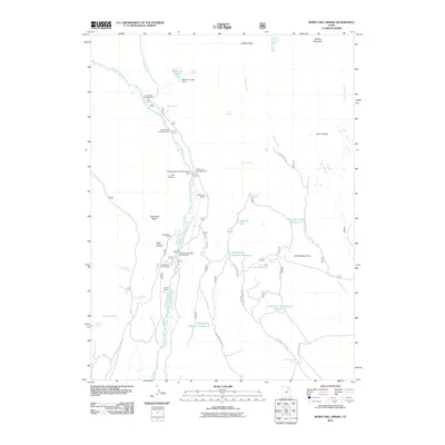
2011 Map of Burnt Mill Spring
USGS Topo · Published 2011About this map
Yellowstone River and Timothy Creek dominate this high-country landscape, where 21st-century water management infrastructure supports the region's ranching and recreational needs. The map documents a complex system of mountain water control, including the Yellowstone Power Diversion Dam, Water Lily Lake Dam, and the Timothy Creek Reservoir. These features, along with the Lower Burnt Mill Spring Reservoir, indicate the critical role of water storage in this part of Duchesne County.
Find a feature on this map
48 named features on this map. Tap any name to fly to it.
Don’t see what you’re looking for? This feature index may not catch every label — zoom into the map to look around manually.
Map Details
Editions of this 2011 Burnt Mill Spring Map
This is the sole edition of this map. No revisions or reprints were ever made.
Other maps of this area

1885 · Uinta
USGS Topo · 1:250,000

1905 · Gilbert Peak
USGS Topo · 1:125,000

1906 · Gilbert Peak
USGS Topo · 1:125,000

1939 · Duchesne
USGS Topo · 1:125,000

1954 · Salt Lake City
USGS Topo · 1:250,000

1958 · Salt Lake City
USGS Topo · 1:250,000

1960 · Salt Lake City
USGS Topo · 1:250,000

1965 · Mount Emmons
USGS Topo · 1:24,000
1965 · Heller Lake
USGS Topo · 1:24,000
1965 · Mountain Home
USGS Topo · 1:24,000