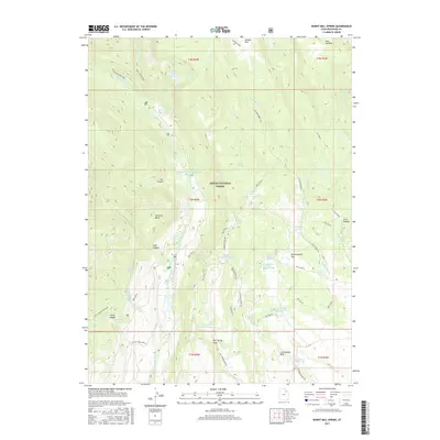
2017 Map of Burnt Mill Spring
USGS Topo · Published 2017About this map
Ashley National Forest dominates this landscape in Duchesne County, where the Yellowstone River and Swift Creek carve through the high terrain. The map illustrates a sophisticated water management system integrated into the natural topography, featuring numerous impoundments such as the Yellowstone Power Diversion Reservoir, Timothy Cr Reservoir, and the Lower Burnt Mill Spring Reservoir. The area's geography is defined by significant transitions in elevation, from the heights of Flat Top Mtn down through Hells Canyon and Cow Canyon. Historical routes and modern access points are well-documented, including the Yellowstone Trail and Swift Creek Trail, which provide passage through the dense forest and around natural landmarks like Harmston Basin. Named springs and secluded lakes, such as McKune Lake and Water Lily Lake, highlight the vital water sources that have supported activity in this part of the Uinta Basin for generations.
Find a feature on this map
56 named features on this map. Tap any name to fly to it.
Don’t see what you’re looking for? This feature index may not catch every label — zoom into the map to look around manually.
Map Details
Editions of this 2017 Burnt Mill Spring Map
This is the sole edition of this map. No revisions or reprints were ever made.
Other maps of this area

1885 · Uinta
USGS Topo · 1:250,000

1905 · Gilbert Peak
USGS Topo · 1:125,000

1906 · Gilbert Peak
USGS Topo · 1:125,000

1939 · Duchesne
USGS Topo · 1:125,000

1954 · Salt Lake City
USGS Topo · 1:250,000

1958 · Salt Lake City
USGS Topo · 1:250,000

1960 · Salt Lake City
USGS Topo · 1:250,000

1965 · Mount Emmons
USGS Topo · 1:24,000
1965 · Heller Lake
USGS Topo · 1:24,000
1965 · Mountain Home
USGS Topo · 1:24,000