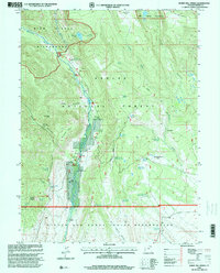
1996 Map of Burnt Mill Spring
USGS Topo · Published 2000About this map
Yellowstone Creek and the Yellowstone River carve through this high-altitude landscape where the Ashley National Forest meets the northern boundary of the Uintah and Ouray Indian Reservation. This 1996 revision documents a specialized high-mountain infrastructure, including the Yellowstone Guard Station and several remote ranching outposts such as Yellowstone Ranch and Crystal Ranch. The map captures a complex water management system vital to the region, featuring the Timothy Creek Reservoir, Mud Spring Reservoir No 3, and a Powerhouse situated near the river. Significant elevation changes are marked by features like Flat Top Mountain and the Yellow Ledges, while the presence of a Quarry and Gaging Station reflects the active utility of the land. For historians, the confluence of Swift Creek and the Yellowstone provides a clear look at the hydraulic and administrative boundaries that shaped Duchesne County at the close of the century.
Find a feature on this map
47 named features on this map. Tap any name to fly to it.
Don’t see what you’re looking for? This feature index may not catch every label — zoom into the map to look around manually.
Map Details
Editions of this 1996 Burnt Mill Spring Map
This is the sole edition of this map. No revisions or reprints were ever made.
Other maps of this area

1885 · Uinta
USGS Topo · 1:250,000

1905 · Gilbert Peak
USGS Topo · 1:125,000

1906 · Gilbert Peak
USGS Topo · 1:125,000

1939 · Duchesne
USGS Topo · 1:125,000

1954 · Salt Lake City
USGS Topo · 1:250,000

1958 · Salt Lake City
USGS Topo · 1:250,000

1960 · Salt Lake City
USGS Topo · 1:250,000

1965 · Mount Emmons
USGS Topo · 1:24,000
1965 · Heller Lake
USGS Topo · 1:24,000
1965 · Mountain Home
USGS Topo · 1:24,000