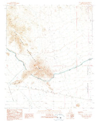
1990 Map of Burnt Mountain
USGS Topo · Published 1990About this map
Burnt Mountain stands as the central landmark of this arid landscape in Maricopa County, anchoring the southeastern reach of the Big Horn Mountains. The 1990 data captures a period of significant water infrastructure development, dominated by the sweeping curve of the Granite Reef Aqueduct as it cuts across the terrain between the Harquahala Plain to the west and the Tonopah Desert to the east. This engineering marvel is flanked by a series of levees and access roads that stand in contrast to the natural topography. Evidence of human utility and transit is found throughout the desert floor, including a Radio Tower, a highway Rest Area, and the isolated Hummingbird Spring. The map documents a sparsely settled but highly modified environment where modern utilities like the Trans Line and various 4wd tracks intersect with the traditional landmarks of the Arizona desert.
Find a feature on this map
13 named features on this map. Tap any name to fly to it.
Don’t see what you’re looking for? This feature index may not catch every label — zoom into the map to look around manually.
Map Details
Editions of this 1990 Burnt Mountain Map
This is the sole edition of this map. No revisions or reprints were ever made.
Other maps of this area

1942 · Vicksburg
USGS Topo · 1:250,000

1954 · Phoenix
USGS Topo · 1:250,000

1957 · Phoenix
USGS Topo · 1:250,000

1958 · Phoenix
USGS Topo · 1:250,000

1960 · Phoenix
USGS Topo · 1:250,000

1961 · Big Horn Mts
USGS Topo · 1:62,500

1962 · Belmont Mts
USGS Topo · 1:62,500

1962 · Cortez Peak
USGS Topo · 1:62,500

1962 · Arlington
USGS Topo · 1:62,500

1969 · Phoenix
USGS Topo · 1:250,000