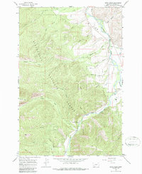
1964 Map of Burnt Ridge
USGS Topo · Published 1986About this map
The Bitterroot National Forest dominates this 1964 survey of the rugged Ravalli County landscape, where the confluence of the West Fork and East Fork forms the Bitterroot River. Near this river junction lies the settlement of Conner, a small focal point for the region's mountain activity. The map reveals a land defined by its drainages and ridges, including the prominent Burnt Ridge and the broad John Bench overlooking the river valley. Evidence of forest management and access is clear through the presence of the Trapper Creek Rural Conservation Center and the Landing Strip situated near Rye Creek. Higher elevations are navigated by a network of primitive routes, notably the Chaffin Pack Trail, while landmarks like Baker Point offer surveying vantage points above Baker Creek.
Find a feature on this map
36 named features on this map. Tap any name to fly to it.
Don’t see what you’re looking for? This feature index may not catch every label — zoom into the map to look around manually.
Map Details
Editions of this 1964 Burnt Ridge Map
4 editions found
Other maps of this area

1901 · Hamilton
USGS Topo · 1:125,000

1956 · Elk City
USGS Topo · 1:250,000

1956 · Hamilton
USGS Topo · 1:250,000

1959 · Hamilton
USGS Topo · 1:250,000

1960 · Elk City
USGS Topo · 1:250,000

1960 · Hamilton
USGS Topo · 1:250,000

1964 · Hamilton
USGS Topo · 1:250,000

1964 · Burnt Ridge
USGS Topo · 1:24,000

1964 · Boulder Peak
USGS Topo · 1:24,000

1964 · Darby
USGS Topo · 1:24,000