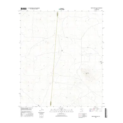
2016 Map of Burnt Spring Hills
USGS Topo · Published 2016About this map
Burnt Spring Hills rises as a distinct topographical anchor in this arid stretch of West Texas, where the landscape is defined by the complex drainage patterns of seasonal watercourses. The border between Culberson and Reeves counties bisects the terrain, illustrating the political division across this open country. Local hydrology is marked by the presence of The Seep, a rare water feature amidst several prominent arroyos including China Draw and Cottonwood Creek. The sparse infrastructure is limited to Co RD 222, which provides the primary access through a region characterized by family-named landmarks and ranching terrain. Other significant relief features include Seven K Draw, Estes Draw, and Hart Draw, which collectively reveal the natural runoff systems that have shaped the local geology over generations.
Find a feature on this map
9 named features on this map. Tap any name to fly to it.
Don’t see what you’re looking for? This feature index may not catch every label — zoom into the map to look around manually.
Map Details
Editions of this 2016 Burnt Spring Hills Map
This is the sole edition of this map. No revisions or reprints were ever made.
Other maps of this area

1921 · Toyah
USGS Topo · 1:125,000

1928 · Kent
USGS Topo · 1:125,000

1954 · Van Horn
USGS Topo · 1:250,000

1954 · Pecos
USGS Topo · 1:250,000

1957 · Pecos
USGS Topo · 1:250,000

1958 · Van Horn
USGS Topo · 1:250,000

1968 · W T Ranch
USGS Topo · 1:24,000
1970 · Toyah SW
USGS Topo · 1:24,000
1970 · Toyah NW
USGS Topo · 1:24,000
1973 · Burnt Spring Hills SE
USGS Topo · 1:24,000