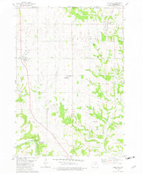
1981 Map of Burr Oak
USGS Topo · Published 1982About this map
The rugged landscapes of Winneshiek County near the Iowa-Minnesota state line are defined by the winding course of Canoe Creek and the southern sweep of the Upper Iowa River. In the early 1980s, the rural community of Burr Oak and the northern settlement of Hesper served as focal points for this driftless-area topography, which is characterized by deeply incised valleys and numerous active Quarry sites. Local educational and civic life is anchored by the North Winneshiek Community Sch and the Luther College Observatory, reflecting the region's commitment to both agriculture and academia.
Find a feature on this map
28 named features on this map. Tap any name to fly to it.
Don’t see what you’re looking for? This feature index may not catch every label — zoom into the map to look around manually.
Map Details
Editions of this 1981 Burr Oak Map
This is the sole edition of this map. No revisions or reprints were ever made.
Other maps of this area

1906 · Decorah
USGS Topo · 1:125,000

1958 · La Crosse
USGS Topo · 1:250,000

1961 · La Crosse
USGS Topo · 1:250,000

1965 · La Crosse
USGS Topo · 1:250,000

1965 · Mabel
USGS Topo · 1:24,000

1965 · Spring Grove
USGS Topo · 1:24,000

1965 · Canton
USGS Topo · 1:24,000

1975 · Decorah 1 NW
USGS Topo · 1:24,000

1975 · Decorah 2 NW
USGS Topo · 1:24,000

1975 · Decorah 1 SW
USGS Topo · 1:24,000