
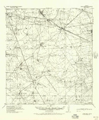
1980 Map of Burrito Tank
USGS Topo · Published 1980About this map
The Texas Mexican railroad line cuts across this South Texas brush country landscape, defining the movement of goods and people between Laredo and the Gulf. Named ranching outposts like Yugo Ranch and the community of Killam are established near seasonal water sources and drainage systems like Aguilete Creek and San Juanito Creek. This 1980 survey captures a region heavily dependent on ranching infrastructure, evidenced by the numerous named earthen reservoirs or tanks scattered across the terrain.
Find a feature on this map
20 named features on this map. Tap any name to fly to it.
Don’t see what you’re looking for? This feature index may not catch every label — zoom into the map to look around manually.
Map Details
Editions of this 1980 Burrito Tank Map
This is the sole edition of this map. No revisions or reprints were ever made.
Other maps of this area

1933 · Becerra Creek
USGS Topo · 1:62,500

1937 · Aguilete Creek
USGS Topo · 1:62,500
1940 · Aguilares
USGS Topo · 1:62,500

1956 · Laredo East
USGS Topo · 1:62,500

1956 · Laredo
USGS Topo · 1:250,000

1965 · Cibolo Ranch
USGS Topo · 1:24,000

1965 · Tios Creek
USGS Topo · 1:24,000

1980 · Blancas Creek North
USGS Topo · 1:24,000
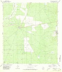
1980 · Mirando City
USGS Topo · 1:24,000

1980 · Piedra Parada Ranch
USGS Topo · 1:24,000
Featured Places
- Ranchitos los Fresnos Colonia, TX
- Ranchitos los Nopalitos Colonia, TX
- Ranchitos los Centenarios Colonia, TX
- Ranchitos las Lomas Colonia, TX
- Ranchitos los Mesquites Colonia, TX