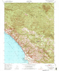
1949 Map of Burro Mountain
USGS Topo · Published 1983About this map
Lucia Range peaks define this coastal stretch of Central California, where the Santa Lucia Mountains meet the Pacific Ocean. This landscape is marked by the interface of the Los Padres National Forest and the northern reaches of the Hunter Liggett Military Reservation, an area that remained largely undeveloped mid-century save for forest management and mining interests. Along the jagged shoreline, Ragged Point serves as a prominent landmark for travelers, while inland, the topography rises sharply to summits like Burro Mountain and Mount Mars. The presence of the Polar Star Mine (Abandoned) near the Monterey and San Luis Obispo county line suggests the area's history of mineral exploration, while the Salmon Creek Ranger Sta and a high-elevation Lookout Tower reflect the critical role of fire watch in these dense forest lands during the post-war era.
Find a feature on this map
30 named features on this map. Tap any name to fly to it.
Don’t see what you’re looking for? This feature index may not catch every label — zoom into the map to look around manually.
Map Details
Editions of this 1949 Burro Mountain Map
3 editions found
Other maps of this area

1919 · Bryson
USGS Topo · 1:62,500

1919 · Piedras Blancas
USGS Topo · 1:62,500

1919 · San Simeon
USGS Topo · 1:62,500

1921 · Cape San Martin
USGS Topo · 1:62,500

1927 · Piedras Blancas
USGS Topo · 1:62,500

1937 · San Simeon
USGS Topo · 1:62,500

1941 · Cape San Martin
USGS Topo · 1:62,500

1941 · Bryson
USGS Topo · 1:62,500

1942 · Bryson
USGS Topo · 1:62,500

1942 · Cape San Martin
USGS Topo · 1:62,500