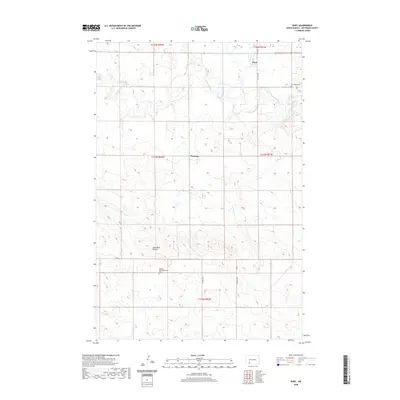
2020 Map of Burt
USGS Topo · Published 2020About this map
The Cannonball River meanders through the central plains of Hettinger County, shaping the geography of this rural North Dakota landscape. Small agricultural hubs like Burt and Watrous anchor the local road network, which follows the rigid grid of the Public Land Survey System. The topography is defined by significant landmarks such as the Hogs Back Buttes in the south, providing a stark contrast to the surrounding drainage basins of Spring Cr and Mehrer Cr. Local history is preserved at sites like the Burt Hope Cem and the Bethany Congregational Cem, which reflect the early 20th-century settlement patterns and the spiritual centers of these prairie communities. This 2020 edition documents the enduring rural character of the region, where township boundaries like t133n r91w and section lines still dictate the movement of people and commerce across the high plains.
Find a feature on this map
18 named features on this map. Tap any name to fly to it.
Don’t see what you’re looking for? This feature index may not catch every label — zoom into the map to look around manually.
Map Details
Editions of this 2020 Burt Map
This is the sole edition of this map. No revisions or reprints were ever made.
Other maps of this area

1953 · Dickinson
USGS Topo · 1:250,000

1957 · Dickinson
USGS Topo · 1:250,000

1966 · Mott South
USGS Topo · 1:24,000

1966 · Mott North
USGS Topo · 1:24,000

1969 · Burt
USGS Topo · 1:24,000

1969 · North Star Butte
USGS Topo · 1:24,000

1969 · Bentley
USGS Topo · 1:24,000
1969 · Burt NW
USGS Topo · 1:24,000
1974 · Plum Butte NE
USGS Topo · 1:24,000

1974 · Long Butte
USGS Topo · 1:24,000