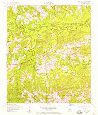
1954 Map of Burton Creek
USGS Topo · Published 1958About this map
The Fort Polk Military Reservation dominates the southern half of this landscape, marking a period of significant military presence in Vernon Parish during the mid-1950s. The northern reaches follow the meandering course of the Calcasieu River, where numerous tributaries like Flat Branch and Big Slough feed into the bottomlands. This area is characterized by scattered rural landmarks that define its social history, including several local congregations such as Union Grove Church and Walnut Hill Church. Evidence of earlier transport and communication is preserved through the inclusion of a dismantled railroad and early telephone lines. Small rural clusters like Hicks appear alongside specialized sites like the Observation post, reflecting the dual nature of this territory as both a quiet residential parish and a strategic military training ground.
Find a feature on this map
28 named features on this map. Tap any name to fly to it.
Don’t see what you’re looking for? This feature index may not catch every label — zoom into the map to look around manually.
Map Details
Editions of this 1954 Burton Creek Map
This is the sole edition of this map. No revisions or reprints were ever made.
Other maps of this area

1937 · Chopin SW
USGS Topo · 1:31,680

1941 · Slagle
USGS Topo · 1:62,500

1942 · Kisatchie
USGS Topo · 1:62,500

1943 · Leander
USGS Topo · 1:62,500

1943 · Kisatchie
USGS Topo · 1:62,500

1944 · Chopin
USGS Topo · 1:62,500

1944 · Slagle
USGS Topo · 1:62,500

1948 · Chopin
USGS Topo · 1:62,500

1953 · Alexandria
USGS Topo · 1:250,000
1954 · Birds Creek
USGS Topo · 1:24,000