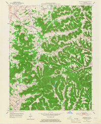
1951 Map of Burtonville
USGS Topo · Published 1967About this map
The North Fork Licking River meanders through the northern reaches of this Fleming and Lewis County borderland, defining a landscape dominated by the prominent Pea Ridge. Small agrarian settlements and family crossroads like Burtonville, Foxport, and Pleasureville are linked by winding roads that follow the valleys of Beechy Creek and Mud Lick Creek. This 1951 field-checked survey captures the rural infrastructure of the mid-twentieth century, documenting a network of one-room schoolhouses and country parishes such as Mt Zion Sch and the Pleasant Valley Ch.
Find a feature on this map
50 named features on this map. Tap any name to fly to it.
Don’t see what you’re looking for? This feature index may not catch every label — zoom into the map to look around manually.
Map Details
Editions of this 1951 Burtonville Map
3 editions found

Other maps of this area

1919 · Vanceburg
USGS Topo · 1:62,500

1929 · Springdale
USGS Topo · 1:48,000

1935 · Springdale
USGS Topo · 1:62,500

1949 · Vanceburg
USGS Topo · 1:62,500

1949 · Charters
USGS Topo · 1:24,000

1950 · Charters
USGS Topo · 1:24,000

1951 · Cranston
USGS Topo · 1:24,000

1951 · Hillsboro
USGS Topo · 1:24,000

1951 · Stricklett
USGS Topo · 1:24,000

1951 · Plummers Landing
USGS Topo · 1:24,000