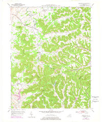
1951 Map of Burtonville
USGS Topo · Published 1978About this map
The North Fork Licking River carves a winding path through this corner of Kentucky, defining the boundary between Fleming Co and Lewis Co. In the early 1950s, the landscape was a patchwork of ridge-top settlements and hollow-bottom farms, connected by winding roads like KY 344 and KY 57. Small rural hubs such as Burtonville, Foxport, and Wallingford anchored these communities, while the terrain's high points, like Sugar Loaf Mtn and Pea Ridge, dictated the layout of local infrastructure. Many community landmarks are noted, including the Pleasant Valley Ch and Oak Ridge Sch. The presence of numerous family-named cemeteries such as Million Cem and Mays Cem provides essential clues for genealogists researching the residents of these wooded hills and winding creek valleys like Beechy Creek.
Find a feature on this map
59 named features on this map. Tap any name to fly to it.
Don’t see what you’re looking for? This feature index may not catch every label — zoom into the map to look around manually.
Map Details
Editions of this 1951 Burtonville Map
3 editions found

Other maps of this area

1919 · Vanceburg
USGS Topo · 1:62,500

1929 · Springdale
USGS Topo · 1:48,000

1935 · Springdale
USGS Topo · 1:62,500

1949 · Vanceburg
USGS Topo · 1:62,500

1949 · Charters
USGS Topo · 1:24,000

1950 · Charters
USGS Topo · 1:24,000

1951 · Cranston
USGS Topo · 1:24,000

1951 · Hillsboro
USGS Topo · 1:24,000

1951 · Stricklett
USGS Topo · 1:24,000

1951 · Plummers Landing
USGS Topo · 1:24,000