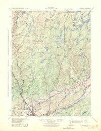
1943 Map of Bushkill
USGS Topo · Published 1944About this map
The Delaware River forms the southern boundary of this 1943 survey, marking the transition from the high ridges of Kittatinny Mountain to the rolling Pocono foothills. The landscape is defined by its recreation and early resort history, visible in the numerous private clubs and campsites like Porters Lake Club, Hiawatha Club, and Camp Tamiment. Transportation and river crossings are central to the area's development, evidenced by historic river infrastructure such as Dimicks Ferry and Walkers Ferry Buckwood Park near Shawnee on Delaware.
Find a feature on this map
113 named features on this map. Tap any name to fly to it.
Don’t see what you’re looking for? This feature index may not catch every label — zoom into the map to look around manually.
Map Details
Editions of this 1943 Bushkill Map
2 editions found

Other maps of this area

1888 · Hackettstown
USGS Topo · 1:62,500

1891 · Wallpack
USGS Topo · 1:62,500

1891 · Delaware Water Gap
USGS Topo · 1:62,500

1893 · Delaware Water Gap
USGS Topo · 1:62,500

1893 · Wallpack
USGS Topo · 1:62,500

1894 · Hackettstown
USGS Topo · 1:62,500

1898 · Hackettstown
USGS Topo · 1:62,500

1900 · Raritan
USGS Topo · 1:125,000

1905 · Raritan
USGS Topo · 1:125,000

1905 · Hackettstown
USGS Topo · 1:62,500
Featured Places
- Blairstown, NJ
- Hardwick Township, NJ
- Lehman Township, PA
- Saw Creek, Lehman Township
- Delaware Township, PA