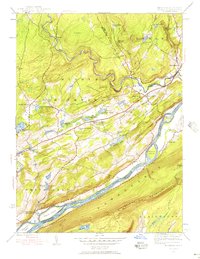
1944 Map of Bushkill
USGS Topo · Published 1956About this map
The Delaware River carves a deep path through the Pocono Mountains region, creating a natural border between Pennsylvania and New Jersey defined by high ridges like Kittatiny Mountain and Big Ridge. In the mid-1940s, this area of Middle Smithfield and Lehman townships was characterized by a landscape of high waterfalls and seasonal resort activity, anchored by the famous Bushkill Falls and Winona Falls.
Find a feature on this map
57 named features on this map. Tap any name to fly to it.
Don’t see what you’re looking for? This feature index may not catch every label — zoom into the map to look around manually.
Map Details
Editions of this 1944 Bushkill Map
7 editions found
Other maps of this area

1888 · Hackettstown
USGS Topo · 1:62,500

1891 · Wallpack
USGS Topo · 1:62,500

1891 · Delaware Water Gap
USGS Topo · 1:62,500

1893 · Delaware Water Gap
USGS Topo · 1:62,500

1893 · Wallpack
USGS Topo · 1:62,500

1894 · Hackettstown
USGS Topo · 1:62,500

1898 · Hackettstown
USGS Topo · 1:62,500

1900 · Raritan
USGS Topo · 1:125,000

1905 · Raritan
USGS Topo · 1:125,000

1905 · Hackettstown
USGS Topo · 1:62,500
Featured Places
- Blairstown, NJ
- Hardwick Township, NJ
- Lehman Township, PA
- Saw Creek, Lehman Township
- Middle Smithfield Township, PA