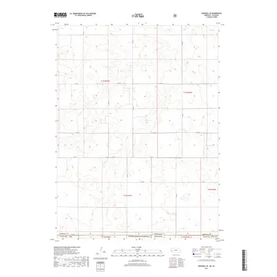
2017 Map of Bushnell SE
USGS Topo · Published 2017About this map
Pawnee National Grassland dominates the southern reaches of this landscape where the high plains of Colorado meet the Nebraska border. The terrain is defined by a series of north-south trending ridges and draws, most notably Sidney Draw which cuts through the northeastern corner. This 2017 survey illustrates the rigid Public Land Survey System grid that organizes this vast grazing territory, with section lines and township boundaries like t13n r57w and t12n r57w dictating the placement of the rural road network. Transportation is primarily limited to gravel county routes such as Co Rd 14 and Co Rd 29, which connect isolated ranching operations across the state line between Weld Co, Colorado, and Kimball Co, Nebraska.
Find a feature on this map
19 named features on this map. Tap any name to fly to it.
Don’t see what you’re looking for? This feature index may not catch every label — zoom into the map to look around manually.
Map Details
Editions of this 2017 Bushnell SE Map
This is the sole edition of this map. No revisions or reprints were ever made.
Other maps of this area

1954 · Sterling
USGS Topo · 1:250,000

1954 · Scottsbluff
USGS Topo · 1:250,000

1958 · Scottsbluff
USGS Topo · 1:250,000

1958 · Sterling
USGS Topo · 1:250,000
1972 · Bushnell SW
USGS Topo · 1:24,000

1972 · Kimball SW
USGS Topo · 1:24,000

1972 · Bushnell
USGS Topo · 1:24,000

1972 · Kimball
USGS Topo · 1:24,000

1972 · Bushnell SE
USGS Topo · 1:24,000

1972 · Oliver Reservoir
USGS Topo · 1:24,000