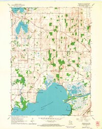
1961 Map of Busseyville
USGS Topo · Published 1964About this map
Lake Koshkonong dominates the southern landscape of this 1961 survey, where its complex shoreline is defined by Stinkers Bay, Gilbert Bay, and Olsons Bay. The northern portion of the lake is marked by several distinct residential and historical areas including Koshkonong Manor, Carcajou, and the whimsically named Vinnie Ha Ha. Ancient history is etched into the terrain at Sylvan Mounds and Koshkonong Mounds, indicating a long-established human presence near the water long before the agrarian settlements of Oakland and Busseyville took shape.
Find a feature on this map
38 named features on this map. Tap any name to fly to it.
Don’t see what you’re looking for? This feature index may not catch every label — zoom into the map to look around manually.
Map Details
Editions of this 1961 Busseyville Map
2 editions found
Other maps of this area

1890 · Sun Prairie
USGS Topo · 1:62,500

1890 · Stoughton
USGS Topo · 1:62,500

1891 · Waterloo
USGS Topo · 1:62,500

1891 · Koshkonong
USGS Topo · 1:62,500

1894 · Waterloo
USGS Topo · 1:62,500

1894 · Koshkonong
USGS Topo · 1:62,500

1896 · Sun Prairie
USGS Topo · 1:62,500

1905 · Sun Prairie
USGS Topo · 1:62,500

1906 · Koshkonong
USGS Topo · 1:62,500

1907 · Sun Prairie
USGS Topo · 1:62,500