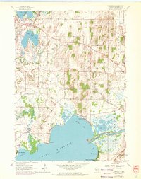
1961 Map of Busseyville
USGS Topo · Published 1972About this map
Koshkonong Lake and its intricate northern shoreline anchor this landscape, where the Koshkonong River and Rock River converge amidst a network of marshes and bays. The map reveals a high concentration of ancient earthworks, specifically Sylvan Mounds to the north and Koshkonong Mounds near Vinnie Ha Ha, suggesting the long-standing significance of these waterways. Residential clusters like Koshkonong Manor and Carcajou occupy the lake's edge, while inland areas like Oakland maintain a rural character defined by local institutions such as Union Ch and Oakland Sch. The Chicago and North Western rail line cuts through the eastern terrain, serving a region punctuated by numerous Gravel Pits and small water bodies like Red Cedar Lake and Lake Ripley.
Find a feature on this map
37 named features on this map. Tap any name to fly to it.
Don’t see what you’re looking for? This feature index may not catch every label — zoom into the map to look around manually.
Map Details
Editions of this 1961 Busseyville Map
2 editions found
Other maps of this area

1890 · Sun Prairie
USGS Topo · 1:62,500

1890 · Stoughton
USGS Topo · 1:62,500

1891 · Waterloo
USGS Topo · 1:62,500

1891 · Koshkonong
USGS Topo · 1:62,500

1894 · Waterloo
USGS Topo · 1:62,500

1894 · Koshkonong
USGS Topo · 1:62,500

1896 · Sun Prairie
USGS Topo · 1:62,500

1905 · Sun Prairie
USGS Topo · 1:62,500

1906 · Koshkonong
USGS Topo · 1:62,500

1907 · Sun Prairie
USGS Topo · 1:62,500