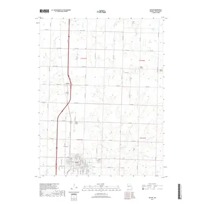
2017 Map of Butler
USGS Topo · Published 2017About this map
Butler serves as a prominent Bates County hub, showcasing a dense grid of streets including W Ohio St, W Fort Scott St, and W Mill St centered around the county's civic heart. This topographic survey captures the landscape at a point of balance between small-town expansion and the enduring agricultural heritage of western Missouri. To the north, the small community of Passaic is situated along the major transit corridor, while the Butler Memorial Airport indicates the region's modern infrastructure. The surrounding countryside is defined by rolling terrain and distinct elevations like Long Mound and Round Mound, with numerous waterways such as Mound Br and Big Deer Cr draining the land. Several local burial grounds, including Oak Hill Cem, Nichols Cem, and Glass Cem, offer vital locations for genealogical research and historical study of local settlement patterns.
Find a feature on this map
62 named features on this map. Tap any name to fly to it.
Don’t see what you’re looking for? This feature index may not catch every label — zoom into the map to look around manually.
Map Details
Editions of this 2017 Butler Map
This is the sole edition of this map. No revisions or reprints were ever made.
Other maps of this area

1887 · Butler
USGS Topo · 1:125,000

1894 · Butler
USGS Topo · 1:125,000

1937 · New Home
USGS Topo · 1:24,000

1947 · Lawrence
USGS Topo · 1:250,000

1950 · Lawrence
USGS Topo · 1:250,000

1956 · Lawrence
USGS Topo · 1:250,000

1961 · Lawrence
USGS Topo · 1:250,000
1961 · Pleasant Gap
USGS Topo · 1:24,000
1961 · Main City
USGS Topo · 1:24,000
1961 · Butler
USGS Topo · 1:24,000